
Backcountry Intelligence
Be Awesome, Don’t Die
Navigate the backcountry with slope shading that adapts to the avalanche forecast, and tours you plan with your people.
Stay out of the red.
Red marks slopes steeper than today’s No Go angle, and the app says it plainly: “Traveling on Red Slopes is High Risk.” Routes are evaluated against the adaptive shading.
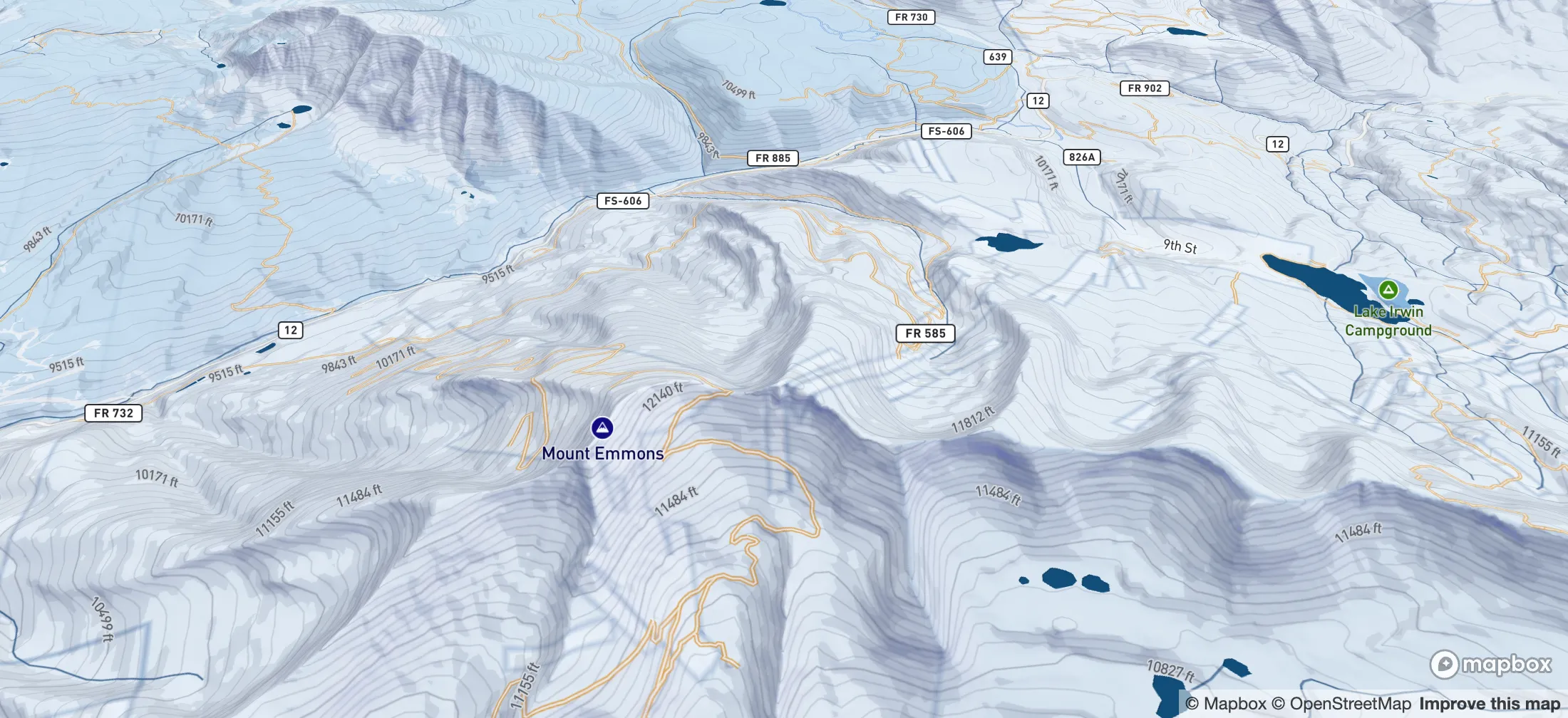
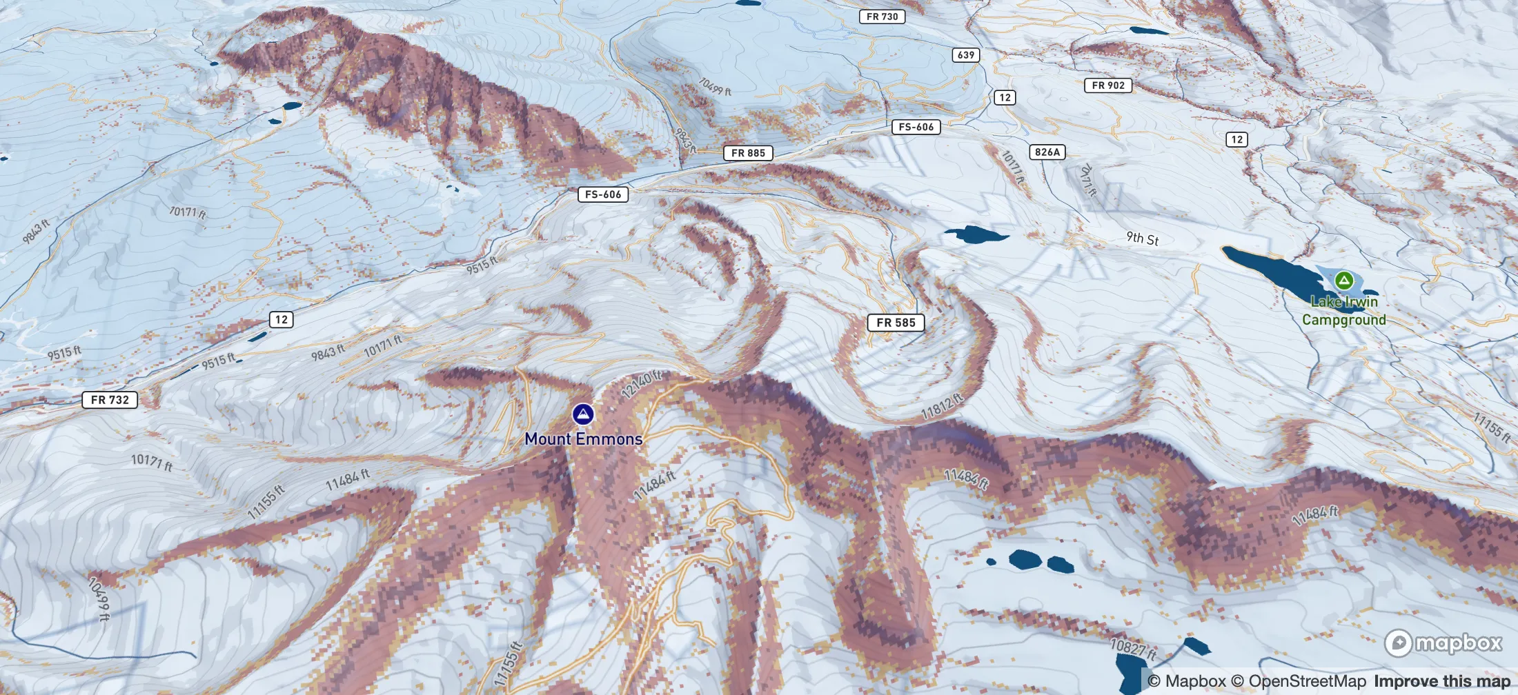
 Moderate
- Slope shading and route risk colors: High Risk
- Slope shading: Use Caution
- Route risk colors: Low Risk
Risk Conditions: Updated Live
We combine forecasts from U.S. avalanche centers with your own field observations to algorithmically map avalanche risk onto the terrain, slope by slope.
Avalanche forecast
Your zone’s avalanche center rates the danger. That rating sets the day’s slope angle limits.
Each slope is shaded by its angle against those limits. On clear slopes, check for Red Avalanche Start zones above, and stay out of their runout.
Your observations
What did you observe? Select warning signs you noticed, or None.
Saving will raise your personal display to Considerable. The official bulletin is unchanged.
Slope angle
Moderate
No Go greater than 34 degreesUse Caution 29 degrees to 34 degrees
Example. Not today’s forecast.
Adaptive slope shading
Shading follows the day’s avalanche danger rating. As the danger rises, more terrain is shaded.
Plan A and Plan B are example routes, not recommendations. Drag to move the map. Hold Ctrl or ⌘ and scroll to zoom, or use two fingers on touch.
One plan for the whole crew.
Tours keep the route, the checklists and your people together, from the forecast to the drive home.
Alex Chen draws Plan A and Plan B over slope shading on the Larkspur Bowl tour in the web app. A moment later the same routes appear on Sam Okafor's phone.
The next morning Sam confirms Review the tour plan at 7:31 AM and Return time at car at 7:33 AM on his phone. In Alex's web app, Required steps updates to 2 of 2 participants have shared every step due so far.
On the mountain, Sam checks in with Taking a break at 11:20 AM. The check-in lands at the top of the tour's Updates in Alex's web app, and Sam's location shows on Plan A.
- Alex Chen · Organizer, in the web app
- Sam Okafor · Teammate, on his phone
Example tour. Names, times and routes are illustrative.
- Alex Chen · Organizer, in the web app
- Sam Okafor · Teammate, on his phone
Plan the route
Start with the forecast, draw Plan A and Plan B, and invite your teammates and tour followers.
Alex Chen draws Plan A and Plan B over slope shading on the Larkspur Bowl tour in the web app. A moment later the same routes appear on Sam Okafor's phone.
Prepare with checklists
Seven checklists in four stages, from Planning at Home to Back at the Car, confirmed right on the tour.
The next morning Sam confirms Review the tour plan at 7:31 AM and Return time at car at 7:33 AM on his phone. In Alex's web app, Required steps updates to 2 of 2 participants have shared every step due so far.
Check in, report your return
Check in with Taking a break or Running late on the way, and report your return back at the car.
On the mountain, Sam checks in with Taking a break at 11:20 AM. The check-in lands at the top of the tour's Updates in Alex's web app, and Sam's location shows on Plan A.
Example tour. Names, times and routes are illustrative.

Pro Tour
Adjust the Adaptive Slope Shading as a professional for the terrain you're navigating
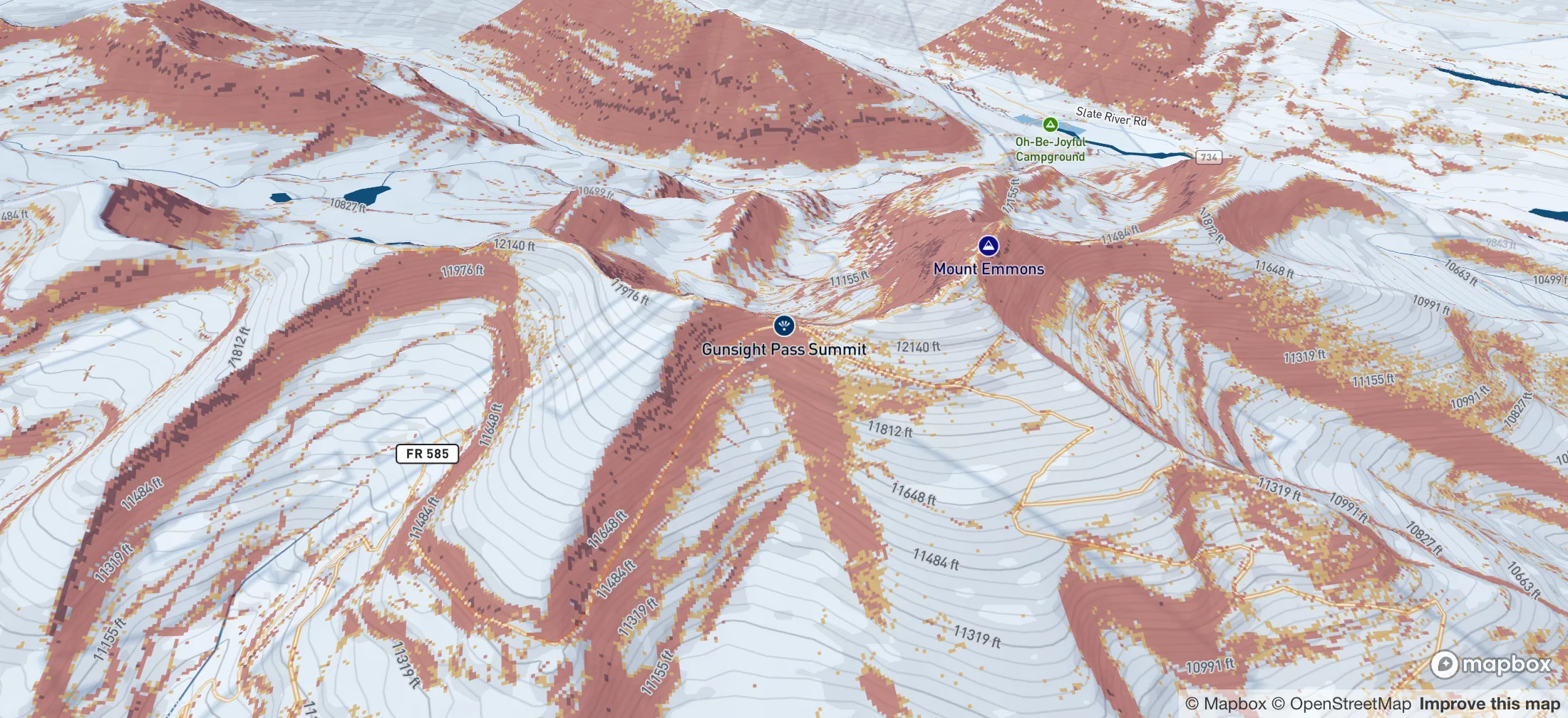

Considerable
Northwest Mountains
Adjust
Adjust · Step 1 of 3
Terrain first.
A personal assessment starts with the ground you plan to travel.
Northwest Mountains
OfficialConsiderableYour displayConsiderableA display setting. A documented decision.
Adjust records your terrain choices and sets your personal map level. Report records warning signs you observed.
I have the avalanche training, experience and knowledge to assess the terrain I plan to travel through. I will document my reasoning. Lowering my personal display can increase my risk. Even experienced professionals make mistakes, and I may be killed in an avalanche. The official forecast remains unchanged.
By continuing, you acknowledge and accept the risks above.
Your map shows the official Considerable. Tap Adjust my map to dial your danger.
Adjust my map is part of Pro. Report warning signs stays free for everyone.
Your personal setting resets automatically within 24 hours, sooner if the official bulletin changes or expires.
A personal assessment describes the terrain you choose. It does not establish that danger is lower throughout the forecast zone.
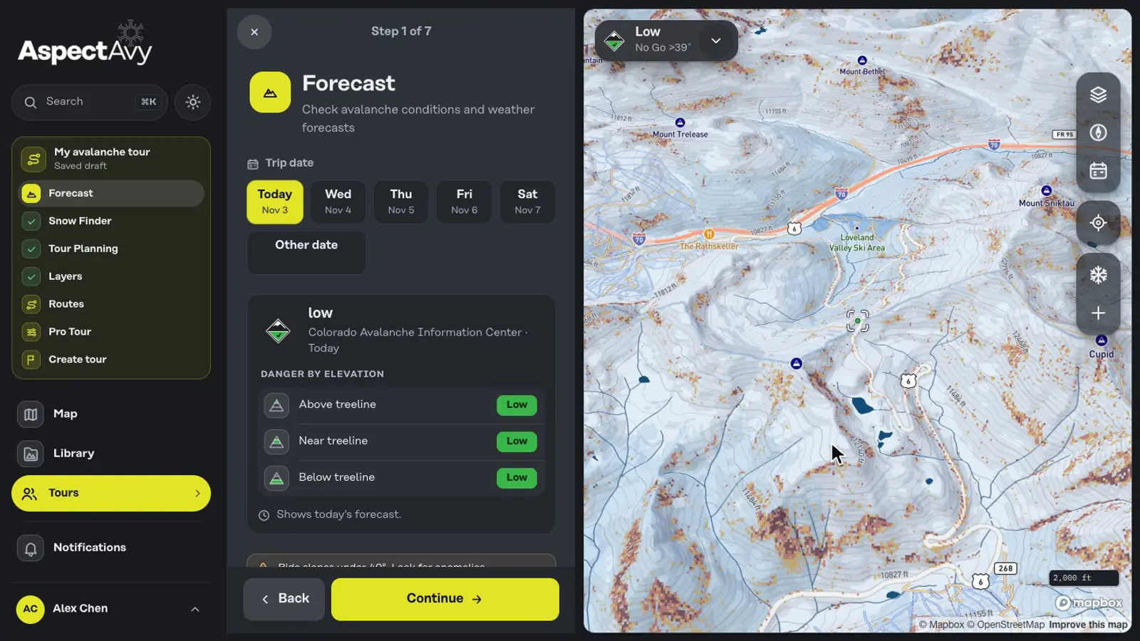
Advanced desktop tour planning
Work through every step on a big screen, from Forecast and Snow Finder to Routes and Create tour, with the map beside you.
Pro Community Membership
Let's be honest, no line, face shot, or untouched couloir is worth dying for. The AspectAvy Pro community is built for mountain athletes who live for adventure, and plan to make it back to share the story with family and friends.

AspectAvy Pro Benefits
Professional Tools
Unlimited use of the app and all tools.
Gear Discounts from Partner Brands
Exclusive member pricing on top outdoor brands.
Community
Access to AspectAvy trips, avalanche courses, and events.
Partner Brands







Gear Discounts from our PartnersPro + Lifetime
Choose Your Plan
Find the membership that fits your season.
Loading current membership options…
Good questions. Clear answers.
A little more context before you head out.
What does AspectAvy help me understand?
AspectAvy brings terrain, avalanche forecast context and your tour plans into one place. Explore slope angle and aspect, review the forecast, and document the decisions you make with your group. It supports your preparation and judgment; it does not determine whether a slope is safe.
Can I use it on my phone and on the web?
Yes. Plan on the web and use AspectAvy on iOS. Your account connects your saved tours and other supported information across both. Check the app and your membership for the tools available to you.
What can I share with my group?
Tour planning brings your route, companions, preparation and sharing together. You choose who receives the plan and which information to share. Teammates and tour followers have distinct roles.
Does sharing a tour replace a rescue plan?
No. Sharing a tour keeps the people you choose informed. It is not a rescue dispatch service, and delivery depends on connectivity and your settings. Carry the right equipment, agree on a plan and know how to contact local emergency services.
Is the map on this page live avalanche advice?
No. This page contains an interactive terrain demonstration and an illustrative image comparison. They do not show current avalanche conditions and must not be used to choose or navigate a route. Open the app and consult the current local avalanche forecast before a trip.
Where can I see membership details?
Your account shows the current membership options, pricing and included tools. This keeps the offer you see here aligned with the options available to your account.
Download App Now For Free
Take AspectAvy into the backcountry on iOS, and plan your next tour on a bigger screen with the web app.